|
wines);
beekeeping (one of the biggest centers in Greece); fishing; forestry (lumber
and resin extraction); metal mining; tourism and to a small extent poultry
and cattleraising. The chief products of Halkidiki are the following:
· wines: Porto
Carras,"Aghioritiko" by Tsantalis(made from Mount Athos grapes) and the
traditional wines of Aghios Nicholaos in Sithonia.
· honey: The
greatest percentage is produced in Nikiti. Part of it is disposed of locally
following canning in Polygyros but most of the production is exported.
· olives and
oil: Produced mainly in the southern and western areas of Halkidiki.
· wood products:
Mainly in northern Halkidiki(Arnea, Paliochori, Megali Panaghia etc.)
Halkidiki’s main contribution to the Greek economy is its metal mines and
tourism. There are three major mining centers : Stratoni (ferro silicon,
galena, sphalerite, etc.), Gerakini (granulite) and Vadvos(granulite).
There are also smaller mines for copper, chromium, manganese, gold and
silver.
Tourist development started in Halkidiki in about 1960, when the
first tourist installations were established by the National Tourist Organisation
(EOT): the Xenia hotels in Paliouri (Kassandra) and in Ouranoupolis (Ouranoupolis),
near the border of Mt.Athos. The big boom, however. Took place during the
period 1968-1975 when big tourist complexes were built in Kassandra
and Sithonia and the beauty of halkidiki was introduced to the tourist
markets of Europe and America. Since then, tourism has continually increased,
because the area has all the beauty of the Aegean islands, plus the advantage
of access by road.
The roads of halkidiki are among the best in Northern Greece. Main roads
are asphalt-paved and the road system is comprehensive (thessaloniki-Moudania,
Kassandra circuit, Sithonia circuit, peripheral north Halkidiki-Stavros-Thessaloniki).
The Pirgadikia-megali Panaghia and Stratoni-Olympias-Stavros sections are
in the last stages of completion  . .
MYTHOLOGY
Many of its distinctive features were known in ancient timew and many tried
to find explanations for them. The ancient name of kassandra was Phlegra,
that is, Place of Fire. It was believed to be the land of the Giants and
the battle ground for the fight between the gods and the Giants, when the
latter tried to drive the Gods from Mount Olympos. 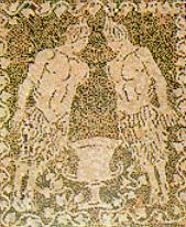 According
to one legend, Enceladus, one of the Giants, was crushed by a rock
which the Gods threw at him. Thus the "earthquake" Giant is today buried
in Kassandra , but, not having been killed, from time to time tries to
free himself from th weight that is crushing him and his struggles result
in earthquakes. All these myths are, of course, not unconnected with the
geological phenomena which are evident in Kassandra: subsidence in the
center of the peninsula, and steam from the hot sulfur springs af aghia
Paraskevi. According
to one legend, Enceladus, one of the Giants, was crushed by a rock
which the Gods threw at him. Thus the "earthquake" Giant is today buried
in Kassandra , but, not having been killed, from time to time tries to
free himself from th weight that is crushing him and his struggles result
in earthquakes. All these myths are, of course, not unconnected with the
geological phenomena which are evident in Kassandra: subsidence in the
center of the peninsula, and steam from the hot sulfur springs af aghia
Paraskevi.
At the other end of halkidiki, Mt athos was named after the giant athos
who, during the famous battlea, threw the mountain at the Gods, as if it
were a small stone. Sithonia received its name from Sithon, son of Poseidon.
His wife was Mendeis and his daughter was Pallini. (Mende was the name
of one of the ancient cities in kassandra, while Pallini is chronologically
the second name of the Kassandra peninsula).
HISTORY
Following
the recent excavations in the cave of Petralona it has been estimated that
the history of Halkidiki goes back 700,000 years. According to the paleontologists
who studied the findings from the cave, the earliest known controlled fire
was lit here, about 700,000 years ago.  The
scull found here during the excavations is estimated to be 250,000 years
old and has given science a new type of man. The
scull found here during the excavations is estimated to be 250,000 years
old and has given science a new type of man.
Many prehistoric settlements have been discovered along the coastline as
well as on the island plains. These settlements show that in 4,000 B.C.
Halkidiki was already a rich, densely populated area where art flourished
and objects of art decorated the people’s everyday life.
Written records refer to the colonisation of Halkidiki as far back as the
Trojan War. The systematic colonisation of Halkidiki by the people of Southern
Greece seems to have started in the 8th century B.C. Colonists came mainly
from Chalkis and Eretria in Euboea.
The earliest historical record we have of Halkidiki comes from Herodotus.
In his writings about the Persian Wars, the father of history repeatedly
mentions Halkidiki and gives historical and topographical details. He describes
the destruction of Mardonius’ fleet by a terrible storm at Athos and the
digging of the canal by Xerxes at the isthmus of the peninsula. Herodotus
mentions all the coastal cities of Halkidiki where Xerxes imposed military
draft and gives important information about the Persian siege of Potidaea
and the slaughter of the Olynthians by the Persian general Artabazus.
Following the Persian Wars (middle of 5th cent. B.C.) most of the cities
of Halkidiki became members of the Athenian League. During the Peloponnesian
War, for which Potidaea was one of the reasons, Halkidiki was for many
years a battleground for the Athenians and Lacedaemonians. As a result
many of the cities of Halkidiki were destroyed and the Halkideans realised
that the only way to survive was to unite forces.
In 168 B.C. Halkidiki, along with the rest of Macedonia, was conquered
by the Romans. During the years that followed, Roman and Italian
merchants and craftsmen settled in its cities.
In the 6th
cent. A.D. Halkidiki was again devastaded, this time by the Huns. For the
period of 6th-9th cent. A.D. we have no information about Halkidiki. During
the 9th-15th centuries, Halkidiki was mainly an agricultural and cattle
raising area. From the monuments and settlements of medieval Halkidiki
only a few ruins remain and the most important of them are as follows:
Castles, Towers, Monasteries.
At the beginning of the 16th century a mint was in operation at Sidirocaussia
(present Sragira) for a short period. This was probably also the time when
the towers were built that still surround the bath today. In 1821 Halkidiki
played an important role in the Greek Revolution. The struggle started
on May 17 in Polygyros and immediately spread to the entire peninsula.
A merchant from Serres who was also a member of the "Filiki Eteria", Emmanuel
Papas, was named the leader of the revolution in Northern Greece. Using
Mt. Athos as his stronghold, he organised fighting groups which were successful
at first but were later defeated by the Turks and withdrew to the peninsula
of Kassandra.
At the beginning of our century, Halkdiki was one of the strongholds of
the Macedonian struggle, also used as a resting place by the fighters.
Guns and ammunition were unloaded here and forwarded to the rebels. Many
people from Halkidiki joined the rebel forces of Pavlos Melas and the other
Macedonian fighters. Thus, in early October 1912, almost 20 days earlier
than Thessaloniki, Halkidiki was once again free.
After 1922, the history of Halkidiki entered a new phase. Thousands
of refugees from Asia Minor, Thrace (Thraki) and Bulgaria settled on its
land. Today, almost 75 years after its third colonisation (the first in
the 8th and 7th cent. B.C., the second during the Roman years and the third
in 1922), Halkidiki is undergoing a unique economic development with the
prospect of becoming one of the model tourist centres of Europe.
|


 The main peninsula
terminates in three smaller ones: Kassandra, Sithonia and Mount Athos (better
known among Greeks as Aghion Oros - the Holy Mountain).
The geomorphology of Halkidiki is interesting. It is a sloping geological
table, rising from the west to the east. Thus in Kalamaria (west coast)
and Kassandra we find most of the plains which are also the most fertile
areas, in the center Mt. Chortiatis (1201 m.), Mt. Cholomon (1165 m.) and
Itamos (in Sithonia, 811 m.) and at the eastern end the magnificent
massif of Mt. Athos (2033 m.). The
three peninsulas which jut into the Aegean Sea make Halkidiki the prefecture
with the longest stretch of coastline in mainland Greece. The coastline
of halkidiki is estimated to be more than 500 km., comprising every type
of landscape. One finds long sandy beaches in Kalamaria, Nikiti, Toroni
and Ierissos; alternating rocks and trees in Sithonia; picturesque small
bays in Vourvourou; and impressive rocks at the Capes of Kassandra, Sithonia
and Athos. Halkidiki does not have any rivers, and this is one of the reasons
why the sea surrounding it, is one of the clearest in greece.
The prefecture of Halkidiki occupies the greatest part of the peninsula,
the northwest section is part of the prefecture of Thessaloniki, and the
peninsula of Mount Athos is an indepedent administrative district. The
prefecture of Halkidiki covers an area of 2,886 sq.km. and has a population
of about 80,000 which is divided among 5 towns and 69 villages. The capital
of the prefecture is Polygyros, with a population of 4,000.
The main peninsula
terminates in three smaller ones: Kassandra, Sithonia and Mount Athos (better
known among Greeks as Aghion Oros - the Holy Mountain).
The geomorphology of Halkidiki is interesting. It is a sloping geological
table, rising from the west to the east. Thus in Kalamaria (west coast)
and Kassandra we find most of the plains which are also the most fertile
areas, in the center Mt. Chortiatis (1201 m.), Mt. Cholomon (1165 m.) and
Itamos (in Sithonia, 811 m.) and at the eastern end the magnificent
massif of Mt. Athos (2033 m.). The
three peninsulas which jut into the Aegean Sea make Halkidiki the prefecture
with the longest stretch of coastline in mainland Greece. The coastline
of halkidiki is estimated to be more than 500 km., comprising every type
of landscape. One finds long sandy beaches in Kalamaria, Nikiti, Toroni
and Ierissos; alternating rocks and trees in Sithonia; picturesque small
bays in Vourvourou; and impressive rocks at the Capes of Kassandra, Sithonia
and Athos. Halkidiki does not have any rivers, and this is one of the reasons
why the sea surrounding it, is one of the clearest in greece.
The prefecture of Halkidiki occupies the greatest part of the peninsula,
the northwest section is part of the prefecture of Thessaloniki, and the
peninsula of Mount Athos is an indepedent administrative district. The
prefecture of Halkidiki covers an area of 2,886 sq.km. and has a population
of about 80,000 which is divided among 5 towns and 69 villages. The capital
of the prefecture is Polygyros, with a population of 4,000.